Recovering degraded areas has an ancient history around the world, although not always told. And knowing success stories in recovery projects brings more than inspiration: it reconnects us with the real possibilities for action to recover degraded areas in our communities.
In today’s article, we will bring some incredible examples of area recovery on different continents. Come and discover!
Project 1 – Chilika Lagoon, Odisha, India
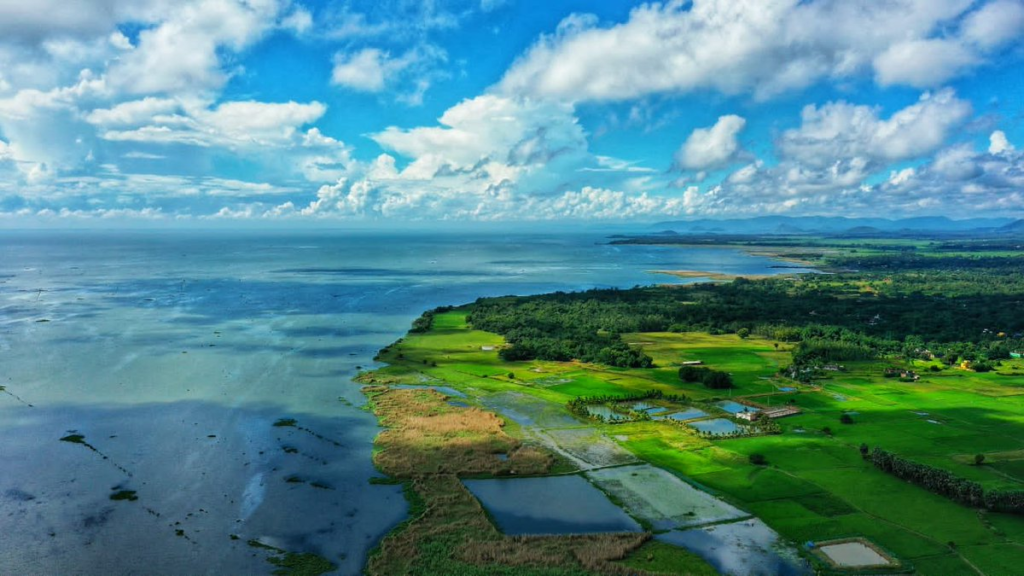
Source: Government of Odisha
The original ecosystem of Chilika
Chilika Laguna is the largest brackish water lagoon on the Asian continent and the second largest coastal lagoon in the world. Located in Odisha, in eastern India, the lagoon receives the flow of the Daya River and flows into the Bay of Bengal. The estimated area of the lagoon is 1,111 km². Due to its estuarine and ephemeral nature, strongly influenced by monsoons and tides, it plays a very important role in regional hydrological regulation.
Like Brazilian mangroves, the Chilika ecosystem is a flooded land, which receives estuarine, monsoon and tidal influences. Similarly, the area is also an important meeting point for migratory birds, as well as being the habitat of an endemic dolphin, the Irrawaddy (Orcaella brevirostris). In other words, a biodiversity hotspot.
Furthermore, the lagoon has a connection area with the Indian Ocean of more than 10 thousand hectares, which makes the water brackish.
Origins of the degradation
Between 1950 and 2000, the region underwent an intense process of environmental degradation, which reduced the lagoon’s connectivity with the ocean. Among the sources of degradation were overfishing and the accumulation of sediment originating from degraded springs.
Furthermore, the loss of the lagoon’s connection with the ocean caused the water to become fresh, which favored the excessive spread of invasive species. Because of this, the surface of the lake has reduced a lot and also affected fish populations.
In addition, fish farming projects (aquaculture) were created in the lagoon converted into a lake, which proved to be disastrous, causing many conflicts and losses of traditional fish production areas.
In this way, not only the environment was degraded, but also the lifestyles of a large group of people and communities involved in traditional fishing in the region. This problem, however, would give rise to one of the most interesting projects for the recovery of degraded areas in the world.
The ecological restoration project
The degradation of the Chilika lagoon area caught the attention of conservationists around the world, but the situation actually began to change following the intense pressure from the people to recover the Chilika flooded area.
Under pressure, the Government of Odisha created the Chilika Development Authority, which acts as a steering committee, bringing together several important actors in the region, especially fishing and farming communities.
From this, new integrated environmental management strategies for the basin were created, in addition to a new outlet from the lagoon to the sea to recreate the lost connection. In parallel to integrated management, vast spring recovery programs were also created throughout the lagoon basin and various support and training actions for fishing communities.
Another important element for the success of this restoration program was the constant communication of the need for integrated management and systematic ecosystem monitoring. As a result, the Chilika lagoon is one of the most interesting projects for the recovery of degraded areas in the world.
The results for local people and nature
After a period of adaptation to interventions and management of the lake basin, the response to the ecological restoration program began to be sustained. Fish production has stabilized at 13,000 metric tons per year and the Irrawaddy dolphin population has grown from 89 to 158 between 2003 and 2015. There have been improvements in the survival of native aquatic plant species and the invasive population has declined significantly.
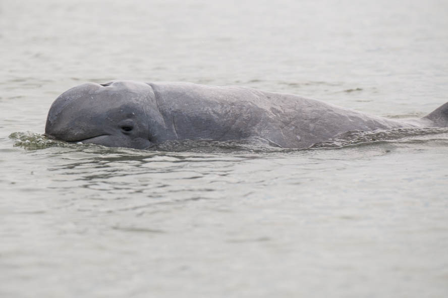
Source: Stefan Brending, Lizenz: Creative Commons by-sa-3.0 de, CC BY-SA 3.0
The area, now the recipient of multiple conservation awards, continues its work on integrated management of the basin. Currently, the biggest problems facing research in the region are increased use of upstream water and rising sea levels, in addition to the increase in extreme events caused by climate change.
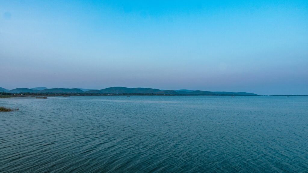
Picture of Subhadeep Dishant in Unsplash
In addition to its recovered ecosystem functions, Chilika Lake is an excellent example of a project to restore degraded areas in the world, and it is beautiful. It is so beautiful that today it is also a tourist destination for the region. If you want to know more about the lake, read the project page here.
Project 2: Salinas do Sacavém Community, São Luís, Maranhão, Brazil
An interesting project to recover areas of the world is located in Maranhão. It is the recovery of a gully in the community of Salinas do Sacavém, in the capital São Luís.
The original ecosystem of the Salinas do Sacavém area
The community of Salinas do Sacavém is located in São Luís, the capital of Maranhão. Therefore, it is within the Amazon biome and has a tropical climate. São Luís Island has some particularities, such as the extensive area of mangroves and one of the largest tidal ranges in the world. This means that the municipality is rich in natural resources, fish and crustaceans, in addition to an abundant popular culture originating from communities of African descent and indigenous peoples.
In environmental terms, São Luís inherits the richness and biodiversity of the Amazon forests. However, nowadays, it is estimated that practically all of the municipality’s original vegetation has been replaced. This means that, in many areas, the Amazon soil was exposed. However, it is important to note that Amazonian soils are very vulnerable to erosion and, depending on the slope, can become gullies.
Origins of area degradation
The colonial occupation of São Luís also gave rise to an urbanization process that did not always respect the region’s environmental limits. One of the oldest cities in Brazil, São Luís had historical importance in different economic cycles in the country. With each new cycle, new waves of migration also arrived, as workers came in search of jobs in different industries at different times in the history of São Luís.
This is the case, for example, of one of the last waves of immigration to the city, which occurred following the installation of the plants of the mining companies ALUMAR (Alumínios Maranhão) and Companhia Vale do Rio Doce (CVRD), currently VALE, between the 1950s. and 1970. Migrants coming from the northeastern hinterland and fleeing the drought went to São Luís to find work.
However, due to the lack of urban planning to accommodate this new population of workers, the city began to have an even greater concentration of areas occupied by irregular housing in areas with fragile soil.
Furthermore, inappropriate land use, such as deforestation, engineering works, speculation
In real estate, the removal of material for construction (laterite, fine sand, silt and clay) in an irregular manner has caused the acceleration of the evolution of gullies in São Luís. This was the case of one of them, the Salinas do Sacavém gully.
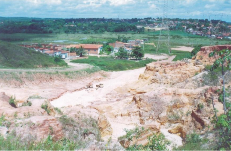
Photo: prof José Fernando Bezerra
This problem is not isolated in São Luís and Maranhão. In fact, the problem has intensified in recent years, which has led to research efforts to solve it.
The project to recover degraded areas of Salinas do Sacavém
In search of a solution to the problem of gullies, which continues to grow in Maranhão, the Salinas do Sacavém area became the target of scientific investigation. This research was part of a scope that included countries in Africa and Asia, which have similar problems and are looking for low-cost solutions to resolve the situation.
Thus, the project “Geomorphology and rehabilitation of degraded areas with bioengineering techniques in the Bacanga basin” began, which researched the use of biodegradable geotextile blankets for the recovery of areas at a high stage of erosion, such as the Salinas do Sacavém gully. .
In addition to an extensive study on the soil properties, slope and technical characteristics of the biomats, the project also had an important element of environmental education offered to the resident community. Also, the community was involved in the production and implementation of geotextile blankets in the areas.
Due to the intensity of urban occupation around the gully, it was also necessary to isolate the area so that it could recover.
The results for local people and nature
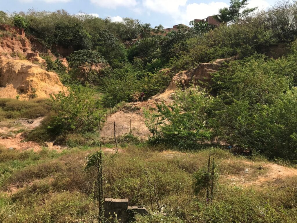
Today, the area has been recovered and the surrounding communities have found new income alternatives by producing biomats for other projects. There is still a lot to be researched, but new initiatives continue to be led by universities to understand the phenomenon of gullies and how to remedy them.
In fact, Brazil also has one of the largest recovery projects for degraded areas in the world, the Atlantic Forest ecological corridors.
Discover other projects that include the use of biomats and communities here at Palmtech.
Project 3 – Loess Plateau, China
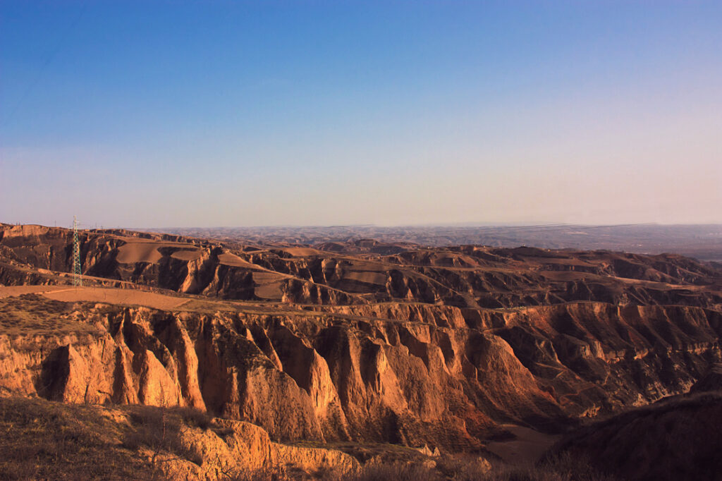
Photo by 黄河山曲, CC BY-SA 3.0
The original ecosystem of the Loess Plateau area
The Loess Plateau or plateau is located in north-central China, in an arid area with intense winds. Its name comes from the deposit of a clastic sediment very similar to mud, loess.
The plateau is also located southeast of the Gobi Desert, in addition to being surrounded by the Yellow River. Despite the presence of other deserts that surround the region, much of the plateau’s loess sediments come from the Gobi Desert.
In turn, these sediments are carried by constant winds and the force of the winter monsoons. As a result, therefore, China’s Loess Plateau is one of the largest deposits of this sediment in the world.
Therefore, due to the characteristics of the loess and the region’s intense climate, the area is highly susceptible to wind erosion (eolian scarps, as we can see in the photograph), ravines and vertical loess faults.
Therefore, China’s Loess Plateau is an area that is highly vulnerable to erosion. In fact, in recent decades, the local environment and climate have changed a lot, including the precipitation pattern, vegetation cover and the proportion of natural environmental hazards.
Origins of area degradation
In the world, there is still a large proportion of the developmental paradigm that the forest is a source of resources and nothing more. Therefore, economically developing an area, in this worldview, means degrading them. This, unfortunately, was also the case in China after the Revolution.
In this sense, the Chinese central government considered, by law, forests as uncultivated agricultural land. Because of China’s need for industrial development, the country created infrastructure construction programs that did not take the environmental aspect into account. In fact, the concept of sustainable development would only emerge much later.
Therefore, for the Chinese government of this period, the objectives of forest management were essentially to provide raw materials and fuel for the development of industry and arable land to produce food for the population.
As a result, unprecedented degradation occurred in the Yangtze (Yellow) River area, which caused increasingly catastrophic droughts. In 1997, the river’s total drought lasted 227 days and for 330 days the river did not reach the sea. Because of this, not only the environment but also the economy and industries dependent on this river were in danger.
On the other hand, in some areas along the Yangtze basin, massive floods have caused enormous losses. It is estimated that around 4000 people died and another 18 million were displaced because of the 1998 flood, in addition to more than 12 billion dollars in damage to infrastructure. With the scenario getting worse, the Chinese government began planning a massive recovery in the region.
The project to recover degraded areas of the Loess Plateau
In 1999, the Chinese government initiated “Grain for Green”, one of the largest projects to restore degraded areas in the world.
However, due to its scale and complexity, the Chinese government took around four and a half years to develop the project and submit it to the World Bank, one of the main sponsors. The primary objectives were the recovery of agricultural productivity and the reestablishment of water flow in rivers and tributaries.
To achieve this objective, the government created a system of payment for environmental services to affected farmers. The idea was to “retire” agricultural areas that already had little or no productivity.
Initially, the project was planned to last 8 years. However, it was extended by a further 8 in 2007. Ten years after its start, around 2010, the project had recovered 15 million hectares of unproductive agricultural land and 17 million hectares of barren drylands, which were converted back to natural vegetation.
The results for local people and nature
After ten years of implementing the Green for Grain project, the results were excellent. Among the effects of the initiative are:
- Return of vegetation
- Return of wildlife
- Recovery of soil microfauna
- Carbon fixation in soil and vegetation
- Presence of pastures in areas previously considered sterile
- Absence of dust clouds, which previously compromised the quality of life of residents
However, the most important result is the return of the different water paths. That is, the rivers have flowed again. As a result, the environment became habitable again.
Another apparent result also occurred in the lives of residents. With payment for environmental services, people were able to start thinking about more functional and sustainable agricultural production methods. In this sense, the region created a “Restoration Economy”, in which previously impoverished people began to play a leading role, which also helps to reduce the country’s inequalities.
The success of the Loess Plateau recovery project has inspired similar programs in other parts of the world, including Egypt, Portugal and Chile and even in the United States. In Burkina Faso, workers are planting trees as part of the Great Green Wall project, a massive project to revegetate areas in sub-Saharan Africa.
Thus, the program has been positive for most areas. However, like any area recovery project, it is necessary to learn from monitoring to continue to advance the sustainable management of the basin. In any case, the program on the Loess Plateau is considered a reference project for the recovery of degraded areas in the world.
As we have seen, recovering degraded areas is an essential activity for the continuity of economic and human development in any context. Here in Brazil, we also have many successful references and we are working to have even more. Keep following to find out more!
Leave a Reply